Consulting/Services : 3D PhotoReal™ Modeling


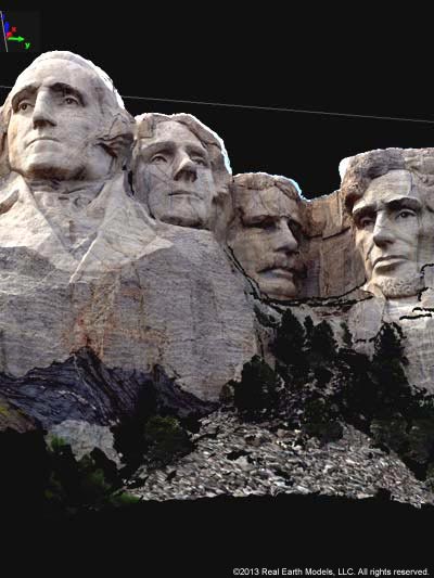
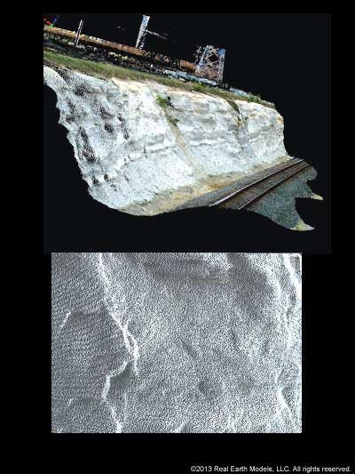
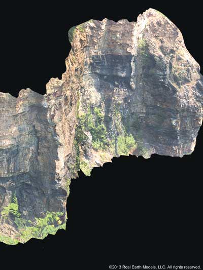
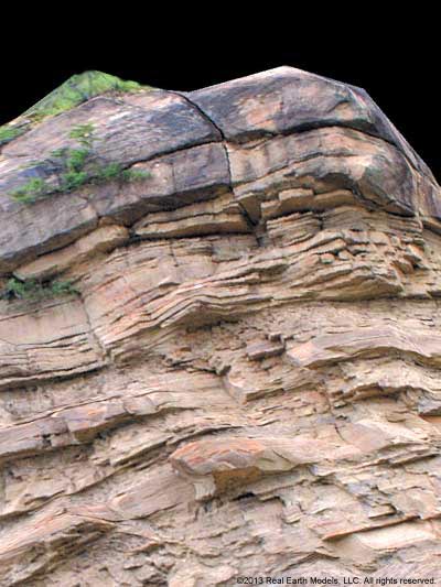
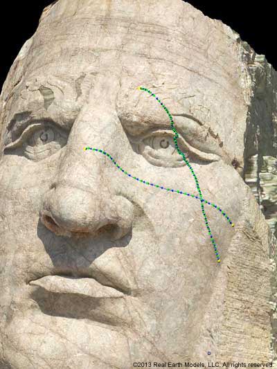
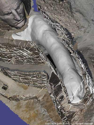
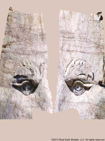
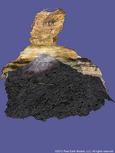
Real Earth Models’ 3D PhotoReal™ Model is a cutting-edge visualization system that integrates the use of different documentation technologies to improve qualitative and quantitative information digitally in 3D models. REM’s PhotoReal™ Models are distinguished by the significant detail and precision achieved. Our proprietary method for transforming point cloud data into our 3D PhotoReal™ Model transcends conventional scanning methods by enabling the viewer to see the scanned object, structure, or terrain accurately, as it really is, in full texture, volume, light and color. Our refined methodology in processing displays information not only from each point in the laser scan, but between the points. PhotoReal™ Models, unique in the industry, retain complete accuracy regardless of changes in either the viewing angle or the viewing distance. Accurate, in-depth, analysis of uncompromised image data is therefore achieved with greater ease, precision, and cost effectiveness. By contrast, viewing a “photorealistic” model from an alternate angle, may present a skewed image, with form and crucial features indistinguishable. The PhotoReal™ Model enhances visualization for any location or object, enabling viewing and feature analysis from any distance, any angle, or any perspective with unparalleled precision.
§ § §
Real Earth Models uses a unique process that synergistically integrates fast, high-resolution laser scanners, photogrammetry, digital cameras, proprietary software, GPS, and GIS. Our processing method accurately matches digital photographs to a highly precise digitized surface to create a true-to-scale, geographically positioned, 3D PhotoReal™ Model. The PhotoReal™ Model we produce is a correct, life-like replica of the actual terrain, object, or structure that can be rotated, examined, and quantitatively analyzed from any perspective without compromising accuracy.
REM’s PhotoReal™ technology is unequalled in the industry. Our 3D models capture the scanned image exactly as it appears at that moment, revealing all aspects of texture and volume, as well as the variables of color, and light. Several features distinguish REM’s PhotoReal™ modeling technology.
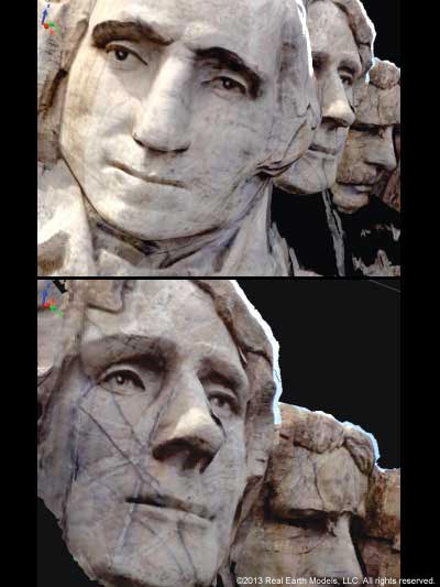
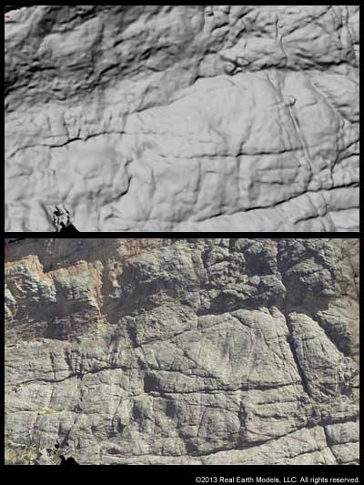
- REM uses a unique process of re-interpolating each pixel from a photograph according to the actual surface delineated from the laser scan. Our method of defining surface features is precise, without distortion or “stretching.” A virtually exact replica of the original scan is created.
- A photo of the real surface is produced which captures all aspects of volume and texture for precise measurement and accurate analysis. Additionally, subtle aspects of actual light, and truer color are revealed and more evenly distributed through our processing technique.
- An exclusive, careful processing method allows for complete rotation of the viewing angle while all features maintain the original integrity with distortion virtually undetectable.
- Our process accomplishes complex procedures rapidly while providing information with greater accuracy and detail than currently available through other scanning methods.
§ § §
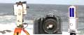
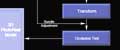
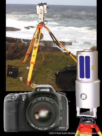
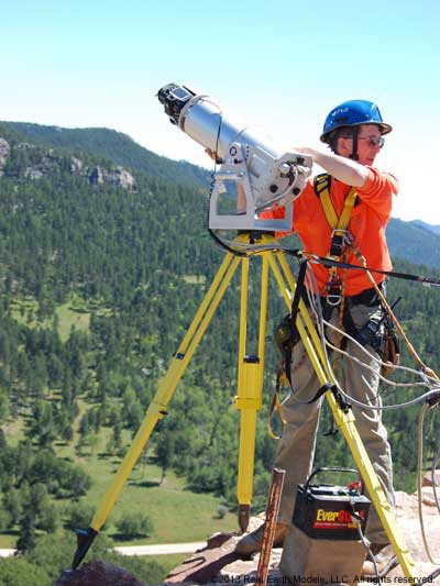
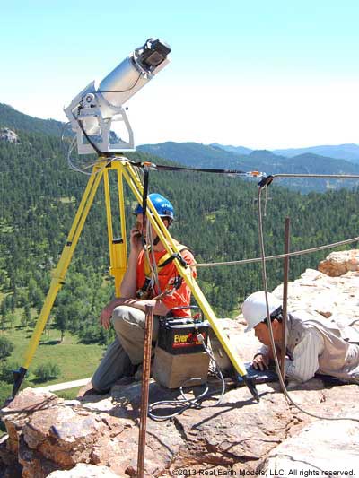
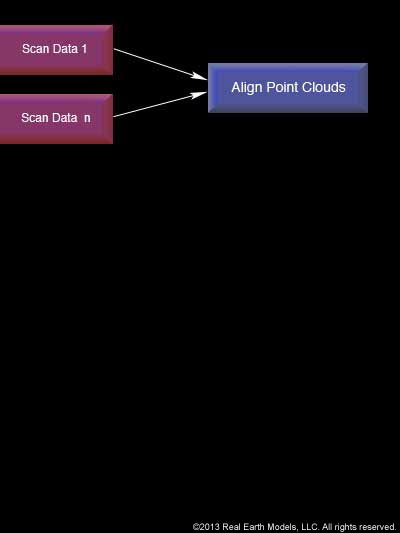
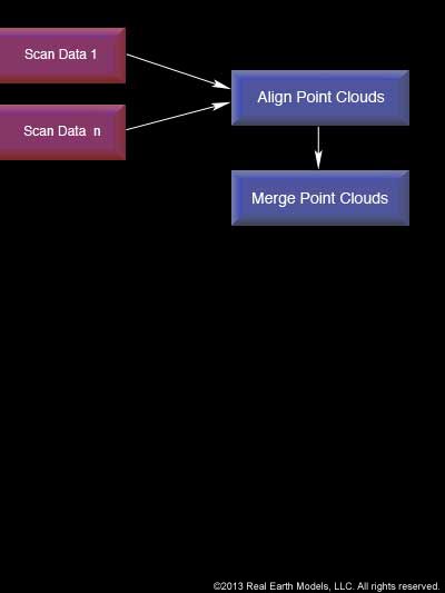
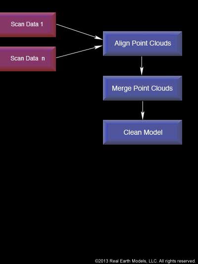
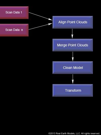
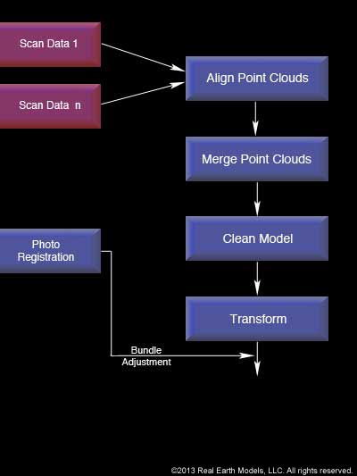
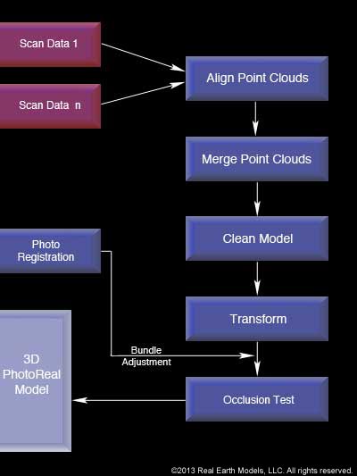
REM’s 3D PhotoReal™ Model is created through a unique process of overlaying high-resolution, digital photography onto the surface generated from laser scanned point clouds. This process integrates high-resolution scanners (including Faro, Riegl, Leica, and Surphaser laser scanners and total stations), GPS (as project dictates), a field computer, and a high-resolution digital camera to accurately match close range digital images to a precise digital surface. By uniquely combining different types of data, including the resolution of digital photographs and the positional accuracy of a laser scan, the 3D PhotoReal™ Model achieves an unparalleled level of precision and completeness in data. Sub millimeter accuracy is achieved in most cases.
The unification of point cloud data with digital photographs that yields the 3D PhotoReal™ Model is generated in a computerized visualization laboratory. Processing is intensive, requiring large multi-core processors, hundreds of gigabytes of storage, and gigabytes of RAM. Proprietary software, used in addition to various CAD and animation software programs, aid in completing our PhotoReal™ projects. Supplemental software includes: Autocad, Revit, NavisWorks, Rhino, 3DS Max, and Zbrush.
The resultant PhotoReal™ Model is highly interactive, with accurate textural information imbedded in a single, unified model that continues to reveal detail as the viewer zooms in closely. The laser data provides precise information about the shape of an object, including minute cracks or subtle hollows. The combined photographic data provides additional detail, including surface texture information, or linkage, at each of the points and between the points. Through our carefully detailed processing, we produce a true, 3D picture of the structure or terrain that can be rotated, examined, and quantitatively analyzed from any perspective and viewed in variable light and color, with all features maintaining integrity.
§ § §
REM’s innovative technology produces visual information that provides cost effective accurate, qualitative data, critical for private and commercial interests, in a broad range of applications. REM’s 3D PhotoReal™ Models greatly improve the viewer’s ability to analyze, measure, document, or reconstruct any object, terrain, or location, and currently serve an array of disciplines that require accurate documentation, measurement, analysis, or problem solving.
Applications for PhotoReal™ technology include: accident investigation and analysis; support for litigation and testimony; building construction/ inspection/ renovation; transportation infrastructure maintenance and upgrades; erosion/ landslide measurement; historical preservation of landmarks; and analysis of mining-related geologic formations; caving; oil and gas; rail transport derailments; video gaming; entertainment industry; virtual museums; and virtual fly throughs that serve business, education, security, cultural tourism, and public service.
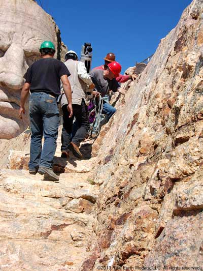
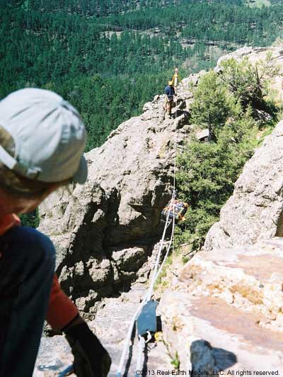
REM’s 3D PhotoReal™ Models result in minimal disruption to the existing surroundings. Laser scanning and photographic data is gathered from vantage points that are safe for field crews. All laser-scanned data can be processed and the 3D PhotoReal™ Model constructed from nearly any location, including at the site.
§ § §
Home | About | Consulting / Services | Portfolio | Site Map
web site ©copyright 2012 - 2025 Real Earth Models, LLC
Problems viewing this web site?
