Consulting/Services : Photogrammetry


Real Earth Models provides complete solutions in close range photogrammetry for a variety of applications. Digital close range photogrammetry is a rapidly emerging field, and REM is leading the way in innovating new applications for this technology, most notably in the fields of geology and oil and gas.
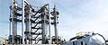
REM’s close range photogrammetry services integrated with our laser scanning methods, provide exceptionally accurate 3D models of oil & gas facilities. Our models enable plant maintenance, refurbishment, documentation, accurate clash reports, safety optimization, and operational design coordination. Other applications include engineering, manufacturing, and archaeology.
Our integration of topographic laser scanning with close range photogrammetry produces highly accurate qualitative data. The distinctive techniques applied in our photogrammetric projects enable geologists, to analyze outcrops, monitor slope displacement, and soil volume. Engineers, and other professional teams are provided insightful data to evaluate historical heritage sites, or document complex buildings and structures. We deliver the highest precision services in close range photogrammetry, rapidly and economically.
§ § §
Close range photogrammetry presents a powerful and versatile technique for acquiring 3D data on objects, buildings, complex facilities, and geological structures and outcrops. Measurements can be accomplished easily, safely, quickly, and accurately. With photogrammetric methods, images of an object can be converted into a 3D model. REM calculates the location and orientation of the photographs with the simultaneously acquired information from laser-scanned data to achieve dimensional measurements and additional surface information. The 3D models we create provide highly accurate data for a variety of structures including karst topography such as sinkholes, as well as tunnels, or facilities with complex detail such as refineries.
Close range photogrammetry has proven advantageous in obtaining the quantitative information used in the study of geological structures. Three-dimensional geometry of the geological structure is crucial to quantifying various geological processes. Our 3D models, created using close range photogrammetry, allow the direct observation of processes such as ground water flow, rock mass stability, dynamically moving landslides, and hydrothermal mineralization, which occur in three-dimensional space.
§ § §
By combining the methods of close range photogrammetry with LiDAR technology, a richness of detail and accuracy is produced. Information obtained with these methods is utilized in advanced analysis of various geological processes. The visualization of geological structures or objects is improved to the degree that details such as cracks and joints, as well as depth, width, and slope can be viewed and measured with precision. Slope displacements can be readily monitored. The degree and rate of weathering that impacts rock formations and the influence of weathering on slope stability is also easily assessed with our close range photogrammetric services. Final results can also be presented in a PhotoReal™ Model.
§ § §
Home | About | Consulting / Services | Portfolio | Site Map
web site ©copyright 2012 - 2025 Real Earth Models, LLC
Problems viewing this web site?
