Portfolio : Geological Study


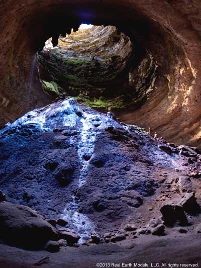


Devil’s Sinkhole, a premier cave in the State of Texas, is a National Landmark, and one of the states deepest caves. The mapping and modeling project at Devil’s Sinkhole added significant quantity and quality data to the speleological knowledge about the cave’s subtle geological and biological features. Devil’s Sinkhole houses a large summertime population of Mexican freetail bats, and it is one of the few caves in the Edwards Group that penetrates to the water table. This natural landmark also provides an excellent opportunity to educate the public about the natural history of bats and their relationship to the ecosystem, as well as the geology and hydrology of the region.
Real Earth Models brought to the Devil’s Sinkhole project, 3D PhotoReal™ modeling technology, which delineated a correct, life-like, replica of Devil’s Sinkhole that can be rotated and viewed from any perspective. The model allows precise, quantitative measurement of physical properties, texture and surface features in natural color. Our digital model depicts all surfaces of the cave accurately and in three dimensions. Should conditions within the cave change for any reason, the cave can be resurveyed. Any subtle change is easily detected when the two models are compared.
REM’s 3D PhotoReal™ Model made several studies of the sinkhole possible: 1) the monitoring of surfaces for erosion, 2) the detection of features that have dislodged or fallen, and 3) the study of formations undergoing dynamic change. The LiDAR models also have applications for the study of seasonal and yearly variances in bat populations as well. Modeling bat roost areas, and measuring guano volume helps estimate the fluctuating bat population.
The PhotoReal™ Model of Devil’s Sinkhole also improves cavers’ safety by providing a visual overview of existing conditions prior to the first journey into the cave. Direction and steepness are readily recognized when viewing the cave's three-dimensional likeness depicted in the model. The ability to zoom into areas not accessible to the caver, especially in vertical environments, allows the identification of potential hazards such as falling rock, thus helping to avoid underground disaster.
The in-depth cave analysis for scientific study is enhanced through the use of the 3D PhotoReal™ Model. Providing more than a pictorial sketch of Devil’s Sinkhole, the model provides a view of the entire geological structure. This enhanced view includes passage systems capable of being modeled and their positioning relative to the cave’s surface. Passage trend information is also illustrated. The PhotoReal™ Model of Devil’s Sinkhole is accurate to within a few millimeters, and depicts texture and other quality detailed information, currently unavailable in any other mapping system.
§ § §
The world’s largest mountain sculpture, Crazy Horse Memorial, was created to honor the Native American People and the famous Lacota (Sioux) leader, Crazy Horse. The Crazy Horse Memorial Foundation requested laser scanning and 3D PhotoReal™ modeling services from Real Earth Models to assist in advancing the carving progress of the mountain sculpture by:
- Providing a 3D PhotoReal™ Model to aid geological analysis of the mountain
- Assisting Crazy Horse Memorial's art and engineering team with 3D dimensional control and geometrical analysis between the sculpture model and the mountain
Crazy Horse Memorial's engineers utilized 3D PhotoReal™ modeling to accurately locate and digitize geological fractures, stratographic rock layers, and rock types throughout the mountain. By combining the information generated from the PhotoReal™ Model with rock properties from field studies, engineers have more detailed data with which to study the rock mechanics and physical characterization. This additional data facilitates precise visualization and decision making in planning and blasting operations.
The memorial foundation’s 1/60th scale model sculptures were also scanned and modeled. The scale models were enlarged to correspond with the mountain scale, and were accurately positioned within the mountain coordinate system. With the 1/60th and mountain models accurately registered, the Foundation's artist and engineers can produce an accurate sculpture model confined by its geological setting, reflecting all the artistic and exquisite elements of a sound masterpiece.
Real Earth Models worked closely with the Foundation's design engineers and artist in developing the enhanced visualization data. Assisting the Foundation in continuing the progress of the mountain memorial, REM provided geological mapping, scale model design, and planning assistance in the Foundation's blasting and carving program.
§ § §
Home | About | Consulting / Services | Portfolio | Site Map
web site ©copyright 2012 - 2025 Real Earth Models, LLC
Problems viewing this web site?
